Posts

This blog has moved - please note

This blog has moved to my new website: http://www.floodriskadvisory.com/ Please visit the site for information and discussion of all things related to flooding risk.  All blog posts past and present will be included in the NEWS page on the site. Thanks for your interest!

Drainage features without mapped flood plains

Image
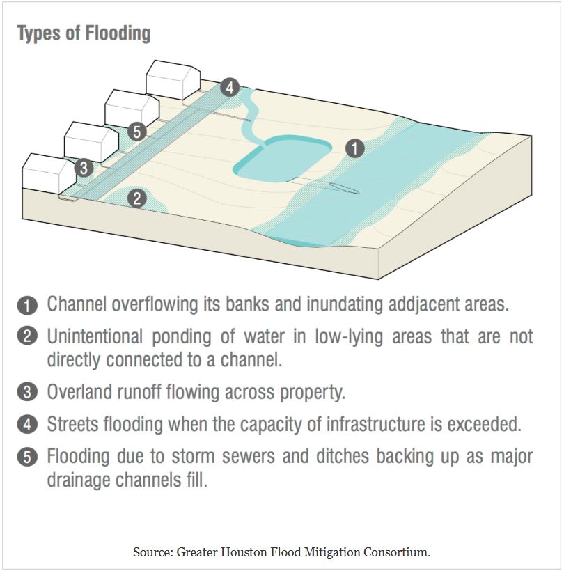
All drainage features whether natural or man-made have flood plains, which are simply the adjacent low areas that fill with water during periods of overflow.  Water overtopping the banks will move to all connected lower areas and remain until drained away by other features.  However, these areas may not be mapped as flood plains on Flood Insurance Rate Maps (FIRM).  As a result, residents and property owners may not realize that they are located in a flood zone. Although unmapped these areas will flood during times when the nearby drainage features overflow. This issue was featured in an April 1, 2018 front page article in the Houston Chronicle article entitled "Damage outside flood plain exposes flaws - 'We just need to start again,' says professor about maps designating flood-risk areas".  The article was written by David Hunn, Matt Dempsey, and Mihir Zaveri and can be viewed at the link below: https://www.houstonchronicle.com/news/article/In-Harvey-s-delu...

City of Houston proposes high priority Harvey recovery and flood prevention projects

Image
On March 21st the city of Houston presented a list of 13 Hurricane Harvey recovery and flood mitigation projects for consideration by the City Council.  These projects are proposed to compete for the first $500 million of an expected $1 billion in FEMA aid released after Harvey. The proposal details are described in a March 22, 2018 Houston Chronicle article by Mike Morris entitled "City lines up Harvey projects - Council receives list of ideas for recovery funds." https://www.houstonchronicle.com/news/politics/houston/article/Houston-identies-700M-in-priority-flood-control-12770379.php#photo-15263041 Most of the proposed projects have already advanced through the concept and design phases and some were already under consideration before Harvey. According to Houston "flood czar" Steve Costello, the high priority projects were selected based on potential impact, the opportunity for the city to partner with other governments to complete them, and the extent...

Check flood control and drainage improvement projects in your area

Image
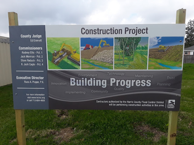
Residents of flood prone areas are well advised to stay informed regarding current and planned flood control and drainage improvement projects.  These projects by design will result in significant reductions to flooding risk.  In some cases the flood hazard maps will be revised to reflect the reduced risk.  This could allow a decrease in flood insurance premiums for the home owner. In my area I noted a project underway in Nassau Bay, a waterfront community in southern Harris County, Texas that has a history of repetitive flooding.  The project is being conducted by Harris County Flood Control District (HCFCD).  It is located on a lot that I had noted previously as the site of a home buyout and demolition after Hurricane Ike, which caused heavy damage to many Nassau Bay homes in 2008. HCFCD maintains an interactive map viewer on which the details of all Maintenance and Capital Improvement projects can be viewed at the link: https://www.hcfcd.org/int...

Check these four critical risk factors before buying a home

Image
There are many things to consider when making the decision to purchase a home.  In low-lying coastal areas such as Houston the risk of flooding is a key factor.  An initial screening based on the four questions below can significantly improve the odds that the homeowner will avoid considerable trouble and expense in the future. 1.  Is the house in or near a flood plain? The flood plains are the areas where water accumulates outside of streams and water bodies in times of overflow.  These areas are at higher risk for flooding by definition.  The Flood Insurance Rate Maps (FIRM) prepared by FEMA show the locations of Floodways and Flood Plains and assign an Annual Percentage Chance Flood Hazard risk to the mapped zones.   However, these definitions are not always accurate predictors for whether or not any given property will flood.  In addition, the FIRMs may be out of date and not properly include increased risk for flooding from facto...

Considerations for neighborhood protected by levee

Image
Residents and potential home buyers in areas where protection from flooding is provided by levee systems may need to consider carefully the actual risk, which may be higher than many assume.  Levees are designed to reduce (but not eliminate) flooding risk.  There may often be no requirement for residents to be provided with an assessment of the specific risk by developers. However, the presence of levees indicates that significant drainage issues exist in the area. The levee system (usually composed of earthen berms, flood gates, and pumps) must perform two functions successfully to prevent flooding: Hold back flood water from outside of the protected area Remove water accumulating inside the protected area Failure of the levee system can result from multiple factors such as: Berms must have sufficient height and strength to hold back impinging flood water Gates must operate properly and be opened/closed at the appropriate times  Pumps must operate properly ...

Example - how to evaluate flood risk for potential property purchase

Image
An article in the Houston Chronicle by Vanessa Brashier dated February 25, 2018 provides a case study for how a prospective property buyer could perform an initial evaluation of flooding risk.  The article is entitled "Liberty County community signals growth is ahead - Encino Estates offers country living and affordability north of Dayton." https://www.houstonchronicle.com/business/real-estate/article/Liberty-County-community-signals-growth-is-ahead-12705439.php To begin the evaluation the prospective property buyer could easily perform two key steps from their home computer as follows: Step 1:  Locate property using Google Maps. In this example I entered the search term "maps encino estates liberty county, tx" and then clicked on the Directions tab on the featured listing as shown below.    The resulting map is shown in Figure 1. Encino Estates is a new development, so the actual area of the subdivision does not show up on the Streets map....

Major Houston area roads in floodplains

Image
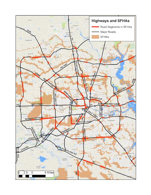
A recent Houston Chronicle article was re-printed in the February 14, 2018 edition of the Bay Area Citizen newspaper.  It was entitled "Major routes through Houston need to be "flood-proofed" to keep freight flowing." The original article can be viewed at the link below: https://www.houstonchronicle.com/news/transportation/article/Ed-Emmett-lays-out-case-to-flood-proof-freeways-12558864.php?cmpid=gsa-chron-result In the article Harris County Judge Ed Emmett encouraged Texas House Transportation Committee members to empower state transportation officials to "flood proof" some major routes so freight can keep flowing into, and through, the region during severe storms. Flooded roads during storms are a well-known problem in the Houston area.  Residents can be caught in dangerous situations due to the rising water and may be blocked from evacuating to safer locations. The Chronicle article mentions that all major freeways in every directio...

Floodplain map vs. topography - Friendswood example

Image
The summary of Harvey damage to properties provided by the City of Friendswood available for review on ArcGIS Online provides a rare opportunity for examination of actual flooding and assessment of the accuracy of the floodplain mapping. The occurrence of significant damage outside of any floodplain can indicate that the maps are not accurate or other factors not accounted for in the FEMA methodology were in effect. The floodplains included on the FEMA Flood Insurance Rate Maps (FIRM) are produced by modeling rainfall amount and intensity, drainage capacity and rate, and the topography.  The topography is the primary factor governing the configuration of a mapped floodplain and it is not subject to variation based on input assumptions. The Friendswood example shows that consideration of the detailed topography along with the floodplain maps can provide a better prediction of where flood damage is likely to occur than use of the FIRM alone. Map #1 shows the portion ...

Lessons from heavy flooding in Friendswood - when to evacuate?

Image
Hurricane Harvey caused widespread damage in Friendswood, a city that straddles the boundary between Harris and Galveston counties about 20 miles southeast of downtown Houston. Friendswood was featured in a February 4, 2018 Houston Chronicle article entitled "After Harvey's floods, Friendswood will allow residents to build at ground level - Effort helps 300 homeowners but puts other at risk." https://www.houstonchronicle.com/news/houston-texas/houston/article/After-Harvey-s-floods-Houston-area-city-will-12540769.php?cmpid=gsa-chron-result The main point of the article is that city officials decided to use an older version of the Flood Insurance Rate Maps (FIRM) to define the Special Flood Hazard Areas (SFHA) where regulations for repair and new construction are in effect.  The older maps are from 1999 and have smaller SFHAs compared to the current (2006) maps. That decision raises many issues that will be discussed in future blog posts.  In addition to pr...

Are there laws for notifying homeowners in Houston about their flooding risk?

An article in the Sunday February 11th edition of the Houston Chronicle presented many issues related to proposed flood mitigation projects.  The article is entitled "Flooding battle plans take shape - Six months after Harvey, local, state leaders eye an overhaul of defenses." https://www.houstonchronicle.com/news/houston-texas/houston/article/Nearly-six-months-after-Harvey-some-traction-for-12567647.php?cmpid=gsa-chron-result Discussed in the article were many proposals that have been in the news in recent months, including: Increased buyouts of flood-prone properties Additions of and improvements for bayous, dams, and reservoirs New, tougher regulations governing development in floodplains Recalculation of methods for measuring rainfall and defining the 100-year storm Drawing of new floodplain maps using the updated rainfall estimates An interesting quote from Houston mayor Sylvester Turner caught my attention since one of the main themes of this blog is ...

Drainage improvement ideas from Ghirardi WaterSmart park in League City

Image
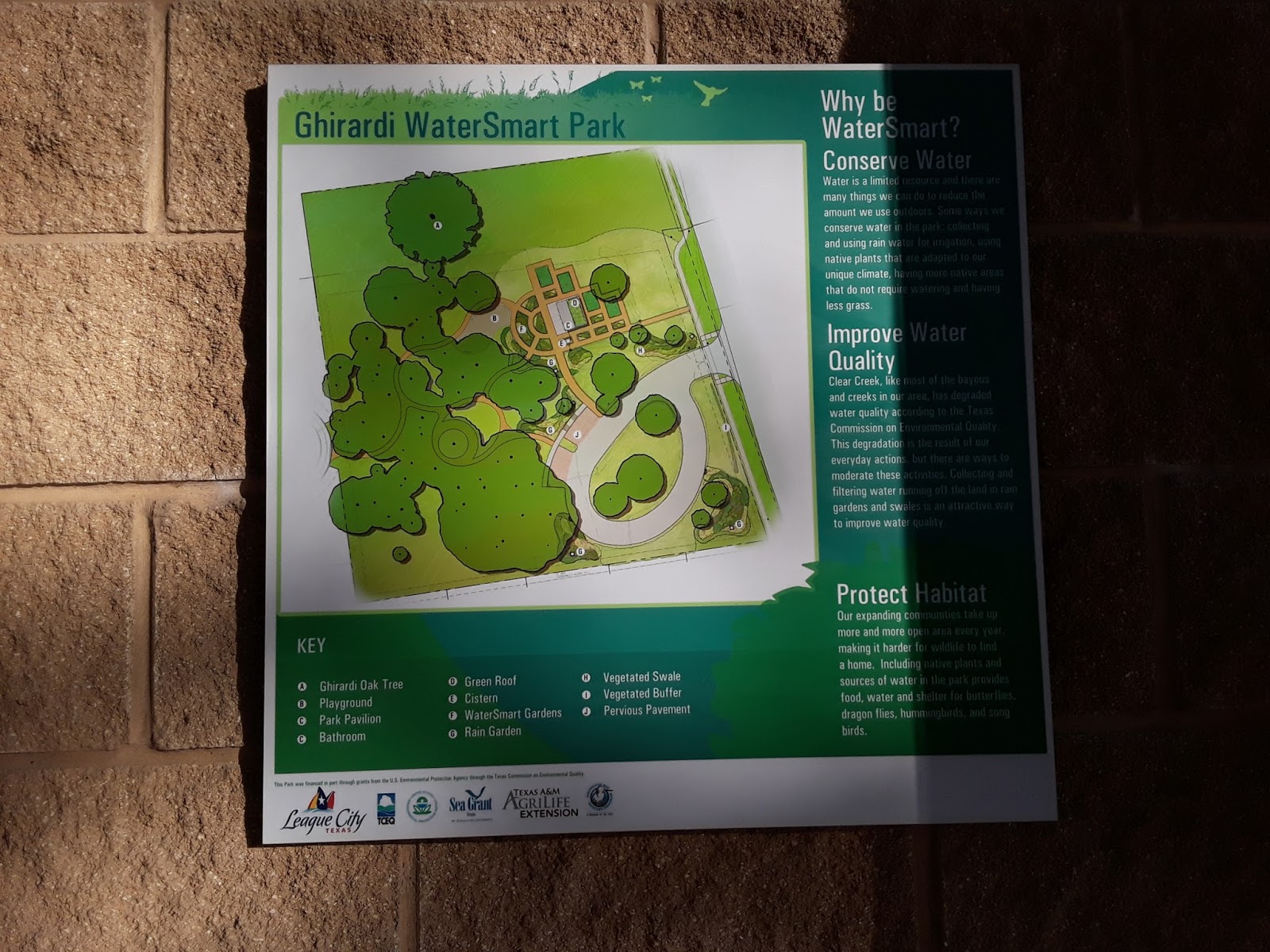
On a recent trip to League City I visited the Ghirardi WaterSmart Park. It is located along Louisiana Avenue just south of FM 518.  The park is built around a few very old live oak trees that have been preserved.  It also has a play structure for the kids. The park is designed to educate the public about various methods to mitigate runoff, conserve water, improve water quality, and protect natural habitats.  Many of the techniques on display could be  easily adopted by neighborhoods and individual homeowners.   The use of pervious pavers on driveways and sidewalks would slow runoff by allowing water to soak into the ground.  The pavers also act as filters for oil and heavy metal particles leaking from cars. Rain gardens can be installed to collect, absorb, and filter storm water.  Rain gardens are bowl-shaped depressions containing various plants and ground cover materials such as mulch.  These act to slow the flow of wat...

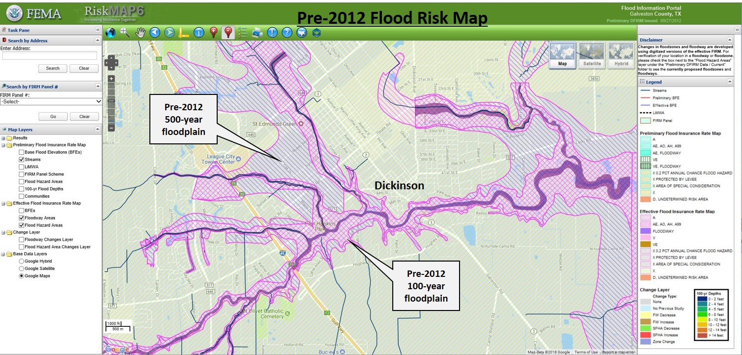
What were the reasons for extensive flooding in Dickinson, TX?

Image
An article in the Galveston Daily News by Marissa Barnett dated January 30, 2018 was entitled "Residents, officials, discuss county drainage woes" . It discussed a meeting held on January 29 where Galveston County residents and officials met to "open conversations about what should be done to alleviate flooding, including ideas about elevating bridges and widening ditches." There were some particularly interesting statements mentioned in the article.  One was that some residents claimed that the FM 517 overpass bridge and other bridges along I-45 likely worsened flooding during Harvey by acting as dams.  Debris stacked up under the bridges or got caught in pilings, keeping water from flowing through.  A resident of a canal home in Clear Creek Village (located in League City along Clear Creek) claimed that development upstream caused issues downstream in area bayous.  There was no mention of whether or not data supporting these claims was presented. The mayo...

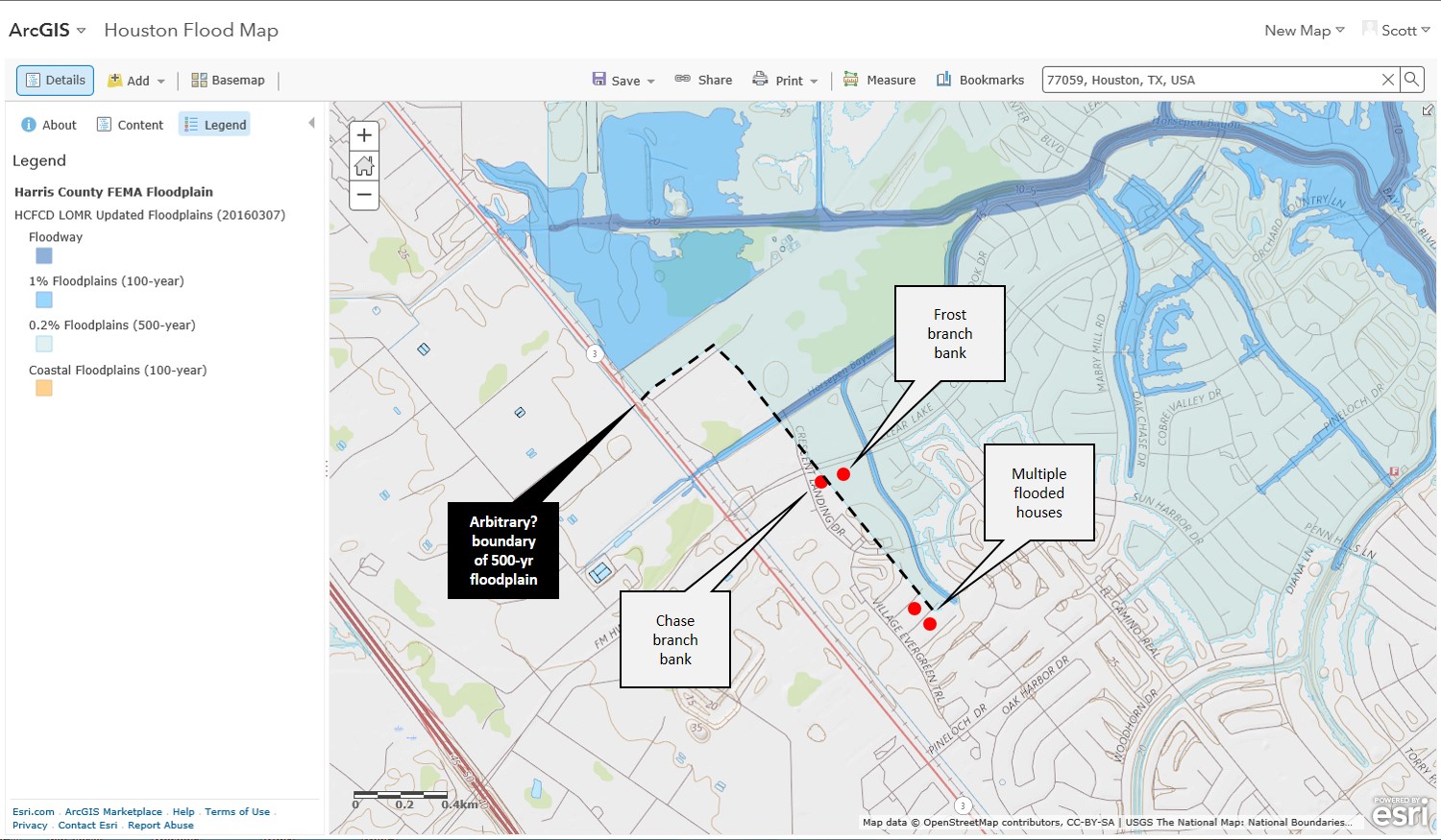
Arbitrary floodplain boundary example

Image
While researching actual damage to businesses during Hurricane Harvey in my local area of Harris County, I found a Houston Chronicle article entitled "Harvey floods damaged 100s of safe-deposit boxes".  The article was written by Paul Takahashi and is dated October 2, 2017. https://www.houstonchronicle.com/business/article/Harvey-floods-damaged-100s-of-safe-deposit-boxes-12247152.php Mentioned in the article is that the Clear Lake City Boulevard branch of Chase Bank was one of nine branches that were flooded during Harvey.  Driving by that area in the aftermath of Harvey I had noticed that the building was closed for repairs.  The nearby Frost Bank branch was also closed.  It is likely that if these two buildings were flooded then a number of other nearby structures in the area were also flooded.  I was able to identify an area of flooded homes south of the Chase branch bank building in the Bay Knoll subdivision. One of the themes of this blog is co...

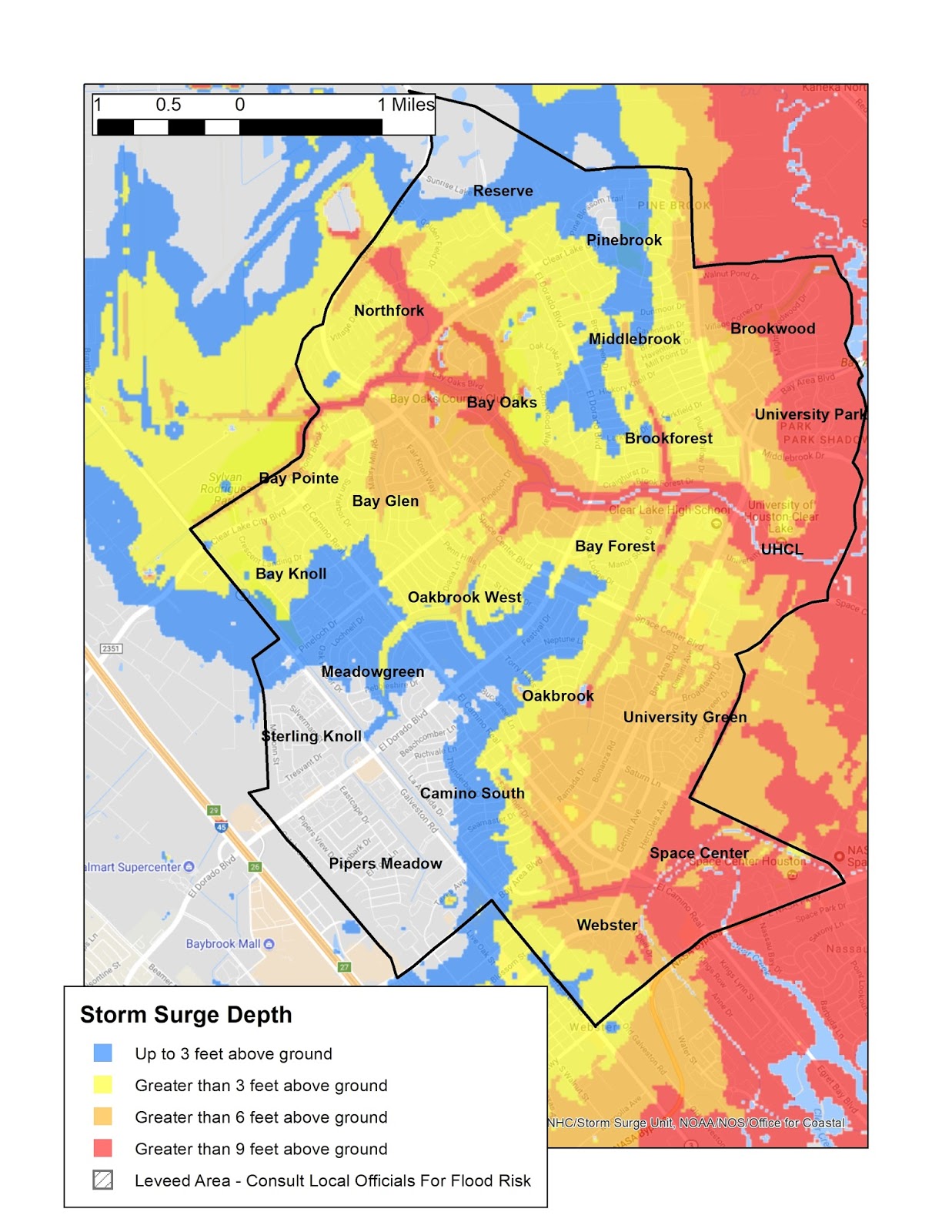
Storm surge prediction for Clear Lake City

Image
A recent article in the Houston Chronicle by Susan Carroll and Mike Ward dated January 5, 2018 presents the case for a new seawall on Galveston Island and Bolivar Peninsula. http://www.houstonchronicle.com/news/houston-texas/houston/article/A-massive-seawall-for-Southeast-Texas-could-save-12477716.php The premise is that a direct hit by a major hurricane to Galveston and Galveston Bay could destroy many billion dollars worth of homes and businesses.  The potential impact will increase in the future by sea level rise resulting from climate change. A proposed 17-foot barrier 60 miles in length could reduce the potential destruction by as much as 80% according to Texas A&M researchers.  This barrier is modeled after a system built in the Netherlands. The flooding mechanisms the barrier would be designed to reduce are: water pushed ahead of strong winds  water rising due to reduced atmospheric pressure  Both of these effects combine to produce s...

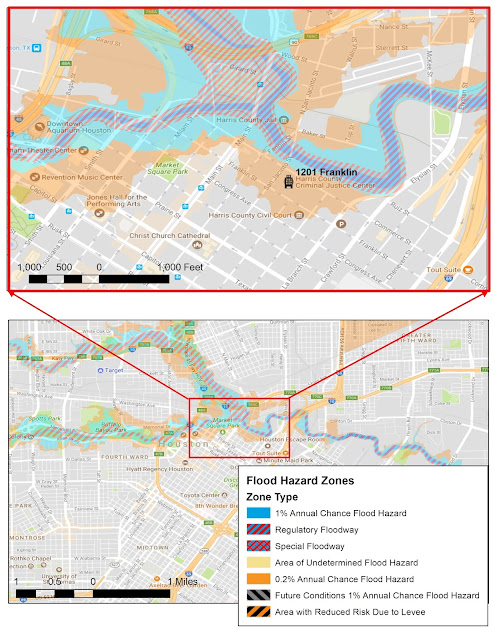
Downtown Houston public buildings in flood plains

Image
An article entitled "Higher ground for the courts - debate rages over retrofit or rebuilding criminal courthouse"  by Brian Rogers appeared in today's (January 7, 2018) Houston Chronicle.  It can also be viewed online at: http://www.houstonchronicle.com/news/houston-texas/houston/article/Hurricane-Harvey-damage-to-Harris-County-criminal-12476558.php?cmpid=gsa-chron-result The article points out that the Criminal Courts Building at 1201 Franklin has been completely unusable since Hurricane Harvey and will remain closed for at least the next six to seven months.  The 20-story building houses county offices and more than 40 courtrooms.  It was constructed for a cost of approximately $100 million and opened in 2000.   Estimates for repair of the building range from $20 million to $100 million.  A prominent attorney quoted in the article questions whether repair of the structure is warranted since it was also flooded during tropical storm Allis...