Major Houston area roads in floodplains
A recent Houston Chronicle article was re-printed in the February 14, 2018 edition of the Bay Area Citizen newspaper. It was entitled "Major routes through Houston need to be "flood-proofed" to keep freight flowing."
The original article can be viewed at the link below:
In the article Harris County Judge Ed Emmett encouraged Texas House Transportation Committee members to empower state transportation officials to "flood proof" some major routes so freight can keep flowing into, and through, the region during severe storms.

Flooded roads during storms are a well-known problem in the Houston area. Residents can be caught in dangerous situations due to the rising water and may be blocked from evacuating to safer locations.
The Chronicle article mentions that all major freeways in every direction away from downtown Houston were closed during Harvey along with portions of freeways that circle parts of the area, such as Loop 610 and the Grand Parkway. Interstate 10 was closed around Shepherd by high waters from Buffalo Bayou. A depressed section of the Sam Houston tollway was damaged by the storm and also closed.
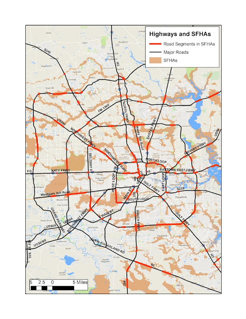
Map #1 below shows all of the major roads in the Houston area in black. Highlighted in red are segments that cross Floodways and the 1.0% Annual Chance (100-yr) floodplains. These two high risk zones compose the Special Flood Hazard Areas (SFHA) shown by the tan shading on the map.

Many, but not all, road segments in SFHAs are elevated or are bridges over waterways. The service roads adjacent to elevated freeways are often at ground level and subject to flooding that prevents access to or from the main lanes. Map #2 is a zoom-in to show detail around the well-known problem areas including I-10 at Shepherd as mentioned above.
From this map it appears that the Southwest Freeway west of Midtown, the Katy Freeway west of Memorial Park, and the Hardy Toll road avoid floodplains and are likely to be clear travel routes during a severe storm.
Readers, do you have a planned evacuation route that avoids flood-prone areas? Have you experienced a situation during a storm where unexpected road closures prevented necessary travel?
For future reference information regarding hurricane evacuation routes and procedures can be viewed at the link below:


Comments
Post a Comment