What were the reasons for extensive flooding in Dickinson, TX?
An article in the Galveston Daily News by Marissa Barnett dated January 30, 2018 was entitled "Residents, officials, discuss county drainage woes". It discussed a meeting held on January 29 where Galveston County residents and officials met to "open conversations about what should be done to alleviate flooding, including ideas about elevating bridges and widening ditches."
There were some particularly interesting statements mentioned in the article. One was that some residents claimed that the FM 517 overpass bridge and other bridges along I-45 likely worsened flooding during Harvey by acting as dams. Debris stacked up under the bridges or got caught in pilings, keeping water from flowing through. A resident of a canal home in Clear Creek Village (located in League City along Clear Creek) claimed that development upstream caused issues downstream in area bayous. There was no mention of whether or not data supporting these claims was presented.
The mayor of Dickinson expressed concern that toughening standards for building in floodplains (such as have already been implemented in Harris County) would cause a negative perception about whether people should choose to build or live there. She believes that the Harvey flooding was exacerbated by issues with the bridges and how quickly water was able to drain from the bayous into Galveston Bay.
One of the main themes of this blog is that the Harvey experience has made it clear that residents and prospective residents of the Houston-Galveston area need to look more closely at flood risk and drainage issues. Everyone is advised to make more informed choices regarding where to buy or rent property. Dickinson provides a very good example since 80% of structures in the city were reported as flooded, and it is quite likely that many of the residents were not aware of the potential for that degree of widespread damage.
The flooding risk for Dickinson can be effectively assessed by examination of:
- Effective Flood Insurance Rate Map (FIRM)
- Preliminary FIRM
- Topographic Map
- FEMA Predicted Damage Model for Harvey
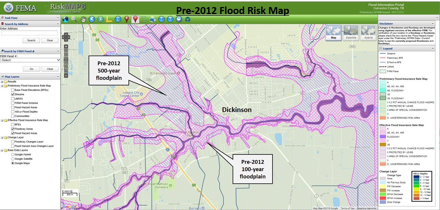
Map #1 is the Effective FIRM for the Dickinson area. Dickinson is located adjacent to the Dickinson
Bayou floodway and four other tributary bayou floodways. Both 100-yr and 500-yr floodplains are present around all of these waterways.
Particularly interesting is the comparison of the Preliminary FIRM dated 9/27/2012 (Map #2) to the pre-2012 FIRM.
Most notable is that the 100-year floodplain (Zone AE) has expanded significantly. The expanded area for the 100-yr floodplain is shaded red on Map #2. The result of this change is that the developed area along the SW side of Highway 3 (and many other areas) was re-classified from a zone of minimal flood hazard risk to a high-risk Special Flood Hazard Area (SFHA). This means that prior to the 2012 map revisions the flood risk appears to have been underestimated for much of the Dickinson area.
The detailed topography from the USGS Digital Elevation Model (DEM) (Map #3) confirms the expanded floodplains on the 2012 Preliminary FIRM. The low area shaded in purple corresponds
closely to the expanded SFHA on the 2012 Preliminary FIRM. This brings up the question of whether or not the floodplain boundaries were arbitrarily drawn prior to 2012 since they obviously did not follow the topography.
Also notable on the topographic map is that very few home lots in Dickinson are elevated above street level. This is a significant issue since the streets and storm drains are the primary drainage features throughout the Houston-Galveston area, and elevation of any structure above street level is a key factor determining risk of flooding. Note the contrast with the Victory Lakes subdivision on the NW corner of the map where lots are obviously higher than street level.
One measure of the unexpectedly high degree of damage in Dickinson is provided by the Damage Assessment Model published by FEMA during Harvey on August 29, 2017. This model predicted flooding depths at parcel centers throughout the Houston-Galveston area using rainfall rates and totals along with the floodplain mapping.
The points of flooding predictions for Dickinson are shown on Map #4. Most of the predicted
flooding damage is confined to the immediate vicinity of Dickinson and Gum Bayous. No flooding was predicted along or west of I-45 however significant damage occurred in both areas. This could mean that other factors (such as debris under bridges) besides floodplain depths, rainfall intensity, and stream drainage rates contributed to the heavy flooding and were not accounted for in the FEMA model.
Please share your thoughts on this subject, particularly if you are a Dickinson area resident or have specific knowledge or concerns to share.


Comments
Post a Comment