Drainage features without mapped flood plains
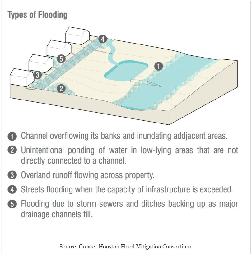
All drainage features whether natural or man-made have flood plains, which are simply the adjacent low areas that fill with water during periods of overflow. Water overtopping the banks will move to all connected lower areas and remain until drained away by other features. However, these areas may not be mapped as flood plains on Flood Insurance Rate Maps (FIRM). As a result, residents and property owners may not realize that they are located in a flood zone. Although unmapped these areas will flood during times when the nearby drainage features overflow.
This issue was featured in an April 1, 2018 front page article in the Houston Chronicle article entitled "Damage outside flood plain exposes flaws - 'We just need to start again,' says professor about maps designating flood-risk areas". The article was written by David Hunn, Matt Dempsey, and Mihir Zaveri and can be viewed at the link below:
According to the article Hurricane Harvey damaged more than 204,000 homes and apartment buildings in Harris county. Almost 75% are located outside of the federally-regulated "100-year" flood plain. More than 55% of the homes damaged during the Tax Day storm in 2016 were outside the flood plain as were more than 33% of homes flooded by the Memorial Day rains in 2015.
These statistics emphasize the inaccuracy of the current flood plain maps in predicting where damage will occur during major storms. The quoted accuracy figures would be improved if the "500-year" flood plains were also considered, especially since the Harvey, Tax Day, and Memorial Day storms all brought greater than 100-year rainfall amounts (12-14 inches in a 24-hour period). However the inaccuracy issue remains and there is considerable debate regarding how the FIRMs can be improved. Even then the new maps for the Houston area are not expected to be available until 2022.
In the meantime what can the resident or property owner do to be better informed regarding the flooding risk when located outside of any mapped flood plain?
A simple check of the distance to nearby flood plains and drainage features can be done using Google Maps and an interactive flood hazard zones viewer such as the one for Harris county at:
A second somewhat more involved exercise is to examine the topography and look for low areas around the drainage features that could flood, regardless of whether or not they are included in the flood plain maps. An example from the Clear Lake City area of southeastern Harris county demonstrates insights possible from these methods.
Map #1 below shows all floodways, drainage features, and flood plains in the study area. The 0.2% Annual Chance ("500-year") and 1.0% Annual Chance ("100-year") Flooding Hazard zones are combined into one comprehensive flood plain. Flooded houses observed by the author after Harvey in 2017 are represented as black dots.
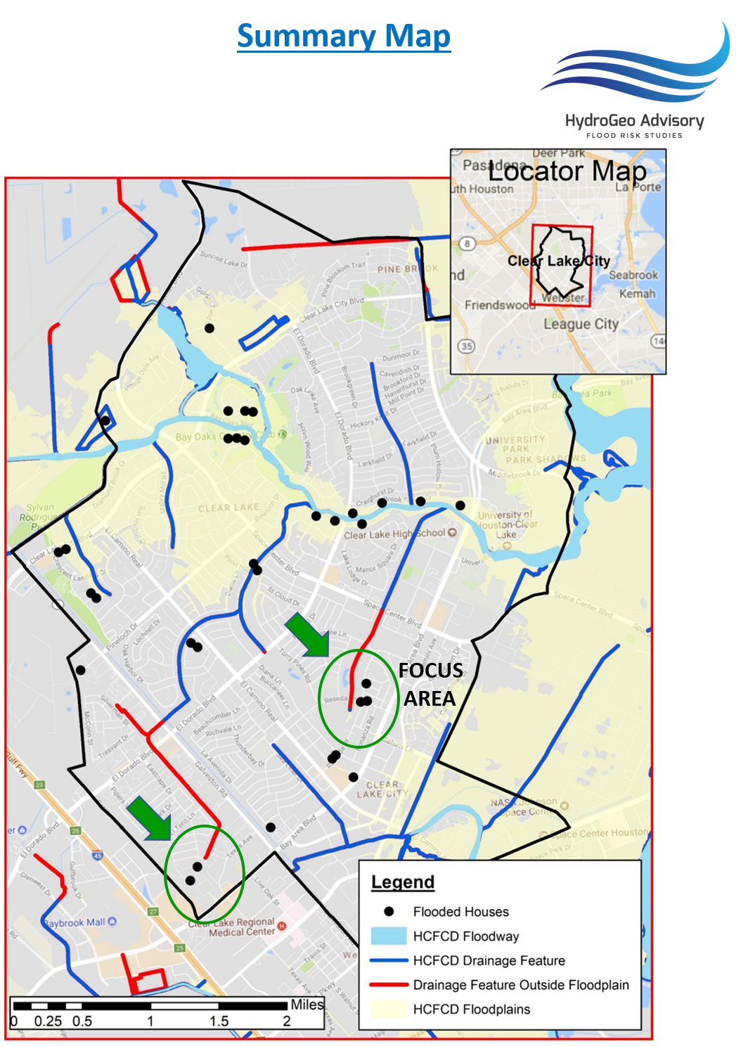
Sources: Harris County Flood Control District, Author
Highlighted in red are portions of drainage ditches that do not have flood plains mapped around them. If effect this means that according to the FIRM these features will never overflow in 100-year or 500-year storm events. This assumption may be valid in theory, however the presence of flooded homes nearby suggests that there was overflow and/or there are low areas nearby where water accumulated.
Green arrows and ovals highlight areas of multiple flooded houses near drainage ditches without flood plains for further examination. Map #2 below is a zoom-in on one of the focus areas showing the same information from Map #1 superimposed on the detailed topography from the Digital Elevation Model (DEM) available from the United States Geological Survey (USGS) at:

Sources: Harris County Flood Control District, Author
In the focus area HCFCD ditch #7741 has a small flood plain mapped at the upstream end. It does not continue northward alongside the drainage feature. However, the lavender-colored areas on the DEM are all at the same depth as the ground inside this small flood plain. The light green areas are several feet higher. This suggests that the actual flood plain configuration could possibly be expanded to include the lavender-colored low areas. Note also that the flooded houses are not significantly elevated above the streets (compare to the neighborhood in the NW corner of the map marked "HIGH").
Readers, are you concerned about the proximity of your property to a drainage feature? Has there been nearby flooding outside of mapped flood plains that suggests the issue pointed out in the Chronicle article map may exist?

Comments
Post a Comment