Posts

This blog has moved - please note

This blog has moved to my new website: http://www.floodriskadvisory.com/ Please visit the site for information and discussion of all things related to flooding risk.  All blog posts past and present will be included in the NEWS page on the site. Thanks for your interest!

Drainage features without mapped flood plains

Image
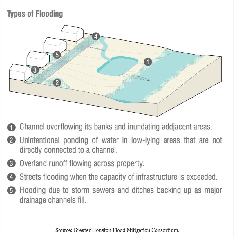
All drainage features whether natural or man-made have flood plains, which are simply the adjacent low areas that fill with water during periods of overflow.  Water overtopping the banks will move to all connected lower areas and remain until drained away by other features.  However, these areas may not be mapped as flood plains on Flood Insurance Rate Maps (FIRM).  As a result, residents and property owners may not realize that they are located in a flood zone. Although unmapped these areas will flood during times when the nearby drainage features overflow. This issue was featured in an April 1, 2018 front page article in the Houston Chronicle article entitled "Damage outside flood plain exposes flaws - 'We just need to start again,' says professor about maps designating flood-risk areas".  The article was written by David Hunn, Matt Dempsey, and Mihir Zaveri and can be viewed at the link below: https://www.houstonchronicle.com/news/article/In-Harvey-s-delug

City of Houston proposes high priority Harvey recovery and flood prevention projects

Image
On March 21st the city of Houston presented a list of 13 Hurricane Harvey recovery and flood mitigation projects for consideration by the City Council.  These projects are proposed to compete for the first $500 million of an expected $1 billion in FEMA aid released after Harvey. The proposal details are described in a March 22, 2018 Houston Chronicle article by Mike Morris entitled "City lines up Harvey projects - Council receives list of ideas for recovery funds." https://www.houstonchronicle.com/news/politics/houston/article/Houston-identies-700M-in-priority-flood-control-12770379.php#photo-15263041 Most of the proposed projects have already advanced through the concept and design phases and some were already under consideration before Harvey. According to Houston "flood czar" Steve Costello, the high priority projects were selected based on potential impact, the opportunity for the city to partner with other governments to complete them, and the extent

Check flood control and drainage improvement projects in your area

Image
Residents of flood prone areas are well advised to stay informed regarding current and planned flood control and drainage improvement projects.  These projects by design will result in significant reductions to flooding risk.  In some cases the flood hazard maps will be revised to reflect the reduced risk.  This could allow a decrease in flood insurance premiums for the home owner. In my area I noted a project underway in Nassau Bay, a waterfront community in southern Harris County, Texas that has a history of repetitive flooding.  The project is being conducted by Harris County Flood Control District (HCFCD).  It is located on a lot that I had noted previously as the site of a home buyout and demolition after Hurricane Ike, which caused heavy damage to many Nassau Bay homes in 2008. HCFCD maintains an interactive map viewer on which the details of all Maintenance and Capital Improvement projects can be viewed at the link: https://www.hcfcd.org/interactive-mapping-tools/a

Check these four critical risk factors before buying a home

Image
There are many things to consider when making the decision to purchase a home.  In low-lying coastal areas such as Houston the risk of flooding is a key factor.  An initial screening based on the four questions below can significantly improve the odds that the homeowner will avoid considerable trouble and expense in the future. 1.  Is the house in or near a flood plain? The flood plains are the areas where water accumulates outside of streams and water bodies in times of overflow.  These areas are at higher risk for flooding by definition.  The Flood Insurance Rate Maps (FIRM) prepared by FEMA show the locations of Floodways and Flood Plains and assign an Annual Percentage Chance Flood Hazard risk to the mapped zones.   However, these definitions are not always accurate predictors for whether or not any given property will flood.  In addition, the FIRMs may be out of date and not properly include increased risk for flooding from factors such as new development and more fre

Considerations for neighborhood protected by levee

Image
Residents and potential home buyers in areas where protection from flooding is provided by levee systems may need to consider carefully the actual risk, which may be higher than many assume.  Levees are designed to reduce (but not eliminate) flooding risk.  There may often be no requirement for residents to be provided with an assessment of the specific risk by developers. However, the presence of levees indicates that significant drainage issues exist in the area. The levee system (usually composed of earthen berms, flood gates, and pumps) must perform two functions successfully to prevent flooding: Hold back flood water from outside of the protected area Remove water accumulating inside the protected area Failure of the levee system can result from multiple factors such as: Berms must have sufficient height and strength to hold back impinging flood water Gates must operate properly and be opened/closed at the appropriate times  Pumps must operate properly and have suffi

Example - how to evaluate flood risk for potential property purchase

Image
An article in the Houston Chronicle by Vanessa Brashier dated February 25, 2018 provides a case study for how a prospective property buyer could perform an initial evaluation of flooding risk.  The article is entitled "Liberty County community signals growth is ahead - Encino Estates offers country living and affordability north of Dayton." https://www.houstonchronicle.com/business/real-estate/article/Liberty-County-community-signals-growth-is-ahead-12705439.php To begin the evaluation the prospective property buyer could easily perform two key steps from their home computer as follows: Step 1:  Locate property using Google Maps. In this example I entered the search term "maps encino estates liberty county, tx" and then clicked on the Directions tab on the featured listing as shown below.    The resulting map is shown in Figure 1. Encino Estates is a new development, so the actual area of the subdivision does not show up on the Streets map.