Download my free report This report describes various methods for assessment of flooding risk in Clear Lake City, TX. It also presents a summary of damage from Hurricane Harvey to supplement the risk assessment. The included map products show publicly available data obtained from FEMA, Harris County, and the City of Houston. The report is an example of what a private citizen with Graphic Information Systems (GIS) mapping knowledge can accomplish. Prospective homebuyers as well as current residents may find this type of study particularly beneficial.
Posts
Insights from detailed topographic map
The United States Geological Survey (USGS) assembles and maintains the National Elevation Dataset (NED). NED is designed to provide national elevation data in a seamless format with consistent datum, elevation unit, and coordinate reference system. These map products are available at the following resolutions: one third arc-second (approximately 10 meters) for the conterminous United States and portions of Alaska, one arc-second (approximately 30 meters) for the conterminous United States, Hawaii, Puerto Rico, U.S. territorial islands, Mexico, and Canada. A resolution of two arc-second (approximately 60 meters) is available for all of Alaska. Refer to the link below to view the maps and for additional information. https://viewer.nationalmap.gov/advanced-viewer/ The highest resolution products however are not seamless but are available for large portions of the United States. These NED are available at one ninth arc-second (approximately 3 meters) resolution. Each
Development has routinely been allowed in floodways
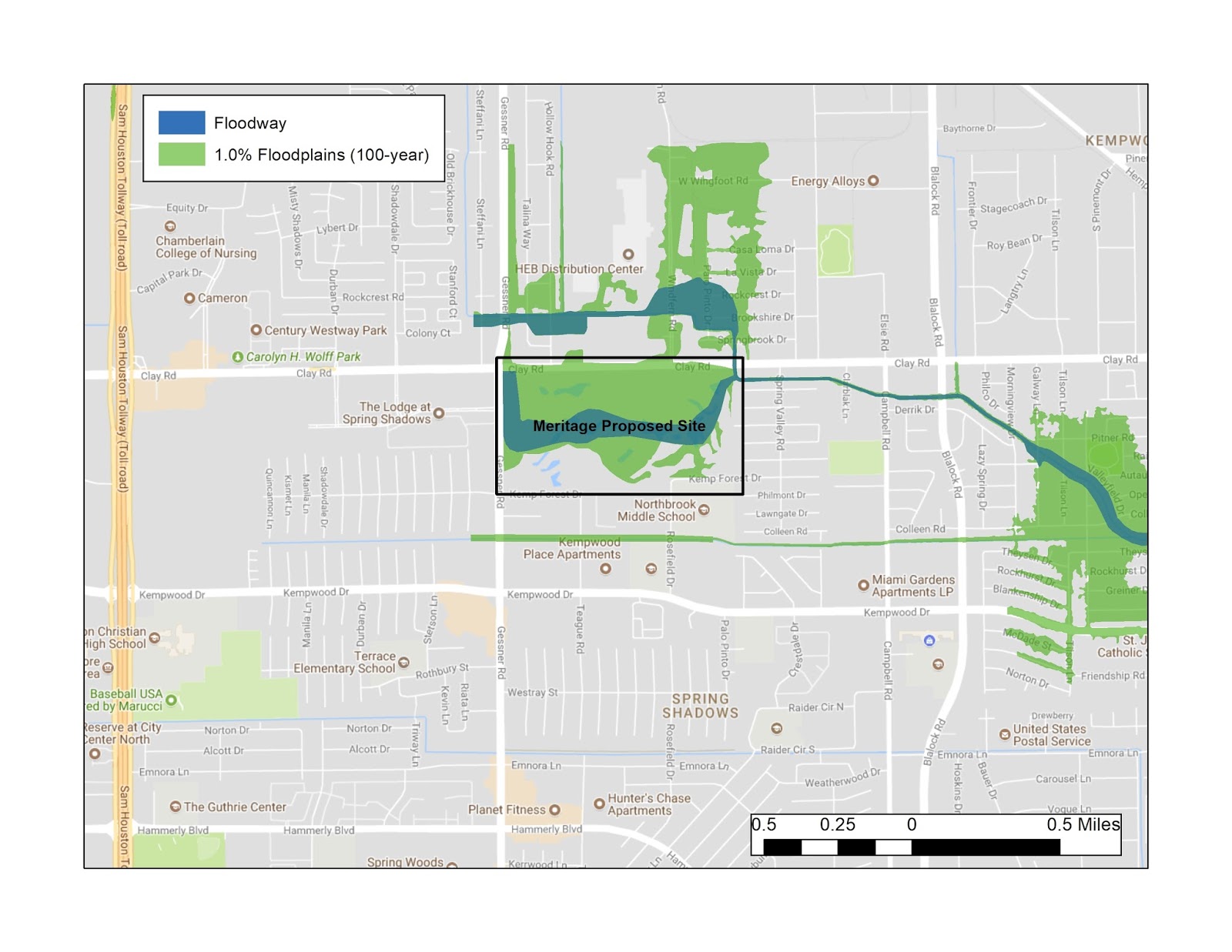
An article in today's Houston Chronicle by Mark Collette and Mike Dempsey (refer to link below) describes how construction of homes in floodways has frequently been allowed to proceed against expert advice. http://www.houstonchronicle.com/news/houston-texas/houston/article/What-s-in-a-floodway-In-Houston-20-000-12409821.php?utm_source=chron&utm_medium=linkmodule&utm_campaign=btfpm Floodways are the areas with the highest risk for flooding damage. They consist of the channel of a river or stream, plus the adjacent land needed to carry away floodwaters. The floodway has some of the fastest-moving water during a flood. The floodways are often bordered by the 100-year flood hazard zones. The article highlights an example from northwest Houston, where Meritage Homes has proposed to build homes on a 151-acre site on Brickhouse Gully, 2 miles east of the Addicks Reservoir (see map #1). Harris County and the City of Houston have previously bought out more than 30
New definition for the 100-year storm?

An article in the Houston Chronicle by Mahir Zaveri dated November 28, 2017 is entitled: "NOAA may reclassify 100-year storm definition because Houston storms have been so bad" The subtitle is "the results could spur sweeping changes to maps, development regulations" http://www.chron.com/news/politics/houston/article/Federal-rainfall-study-shows-dramatic-growth-in-12386006.php It states that the National Oceanic and Atmospheric Association (NOAA) has conducted an update of rainfall data analysis that shows that the 100-year storm has risen by three to five inches across Harris County. The last study of this type was in 2001. The results of the new study will be released in May 2018 following peer-review. The 100-year floodplain is a crucial standard because it is the basis for regulations regarding new development, drawing of floodplain maps, and the design of detention basins and flood control projects. The floodplain maps are built using mo
Exploration Green project - significant mitigation of flooding in Clear Lake City?
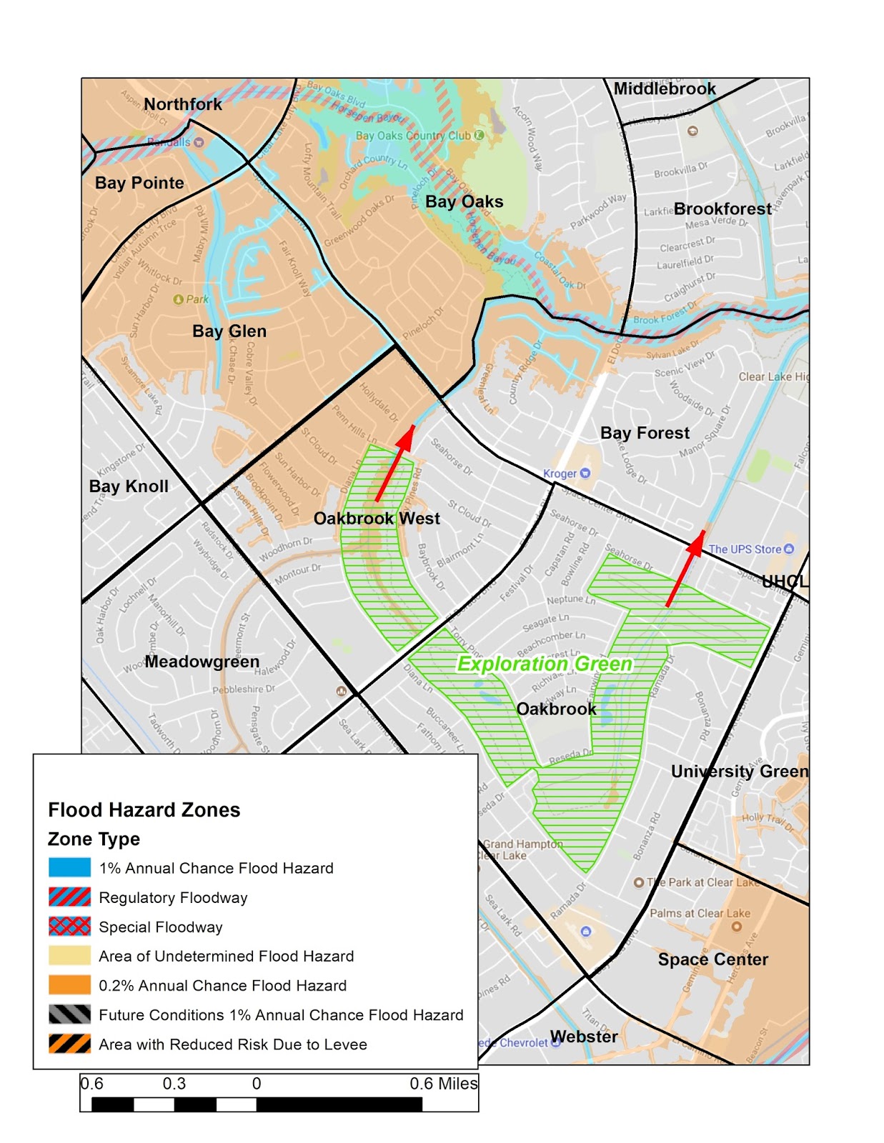
A November 17, 2017 article by Katie Riordan in the Texas Tribune entitled "In search of a flood fix, one Houston community turned to a golf course" summarizes the Exploration Green project. https://www.texastribune.org/2017/11/17/search-flood-control-solution-one-houston-community-turned-golf-course/ Many Clear Lake City residents are familiar with this project, which is now in the early phases of development. It is a joint effort by Exploration Green Conservancy and the Clear Lake City Water Authority (CLCWA) to convert the 227-acre site of the defunct Clear Lake Golf Club into a series of five storm water detention ponds surrounded by hike and bike trails, wetlands, and greenbelts. For details on the Exploration Green project please refer to the link below: http://www.clcwa.org/explorationgreen.htm During Hurricane Harvey the Phase 1 detention pond (in the area south of Reseda Drive between Diana and Ramada) was mostly complete and did act to mitigate f
Extra attention to 500-year flood plains - University Green example

A University Green resident via social media pointed out an example of repeated flooding outside of any Special Flood Hazard Area (SFHA) and away from any bayous. University Green is located in the southeastern portion of Clear Lake City immediately south of the University of Houston - Clear Lake campus. It is adjacent to the western border of Johnson Space Center (see first map). Drainage from the area flows into a ditch that runs southward ultimately connecting to Cow Bayou near the intersection of El Camino Real and East Medical Center Boulevard. The resident mentioned repeated episodes of patio homes being flooded in the central portion of the neighborhood in the vicinity of Ivy Grove and Plumbwood (see second map). The zoomed-in view shows that the 500-year flood plain (zone of 0.2% Annual Chance Flood Hazard) extends into this area from the east. There is a bowl-shaped low area that is coincident with Barleton Way and Plumbwood Way. During heavy rainfal
Houston may force hundreds of residents to raise their homes
The Houston Chronicle ran another front page article today regarding flooding issues in Houston. The title is "Harvey damage could force hundreds in Houston to raise their homes" by Nancy Sarnoff. http://www.houstonchronicle.com/business/real-estate/article/Harvey-damage-could-force-hundreds-to-raise-their-12411490.php To summarize some property owners that flooded during Harvey will need to elevate their homes if they want to continue living there. If the affected properties are substantially damaged and not currently compliant with the city's current elevation standard they will be required to bring the property into compliance. The standard is that the lowest floor must be 12 inches above the base flood elevation (BFE), or 18 inches in a floodway. The initial group of properties to be notified of this new requirement does not include any in the Clear Lake City area, although the article implies that there are more properties yet to be notified. Accordi
New flood plain rules for Harris County
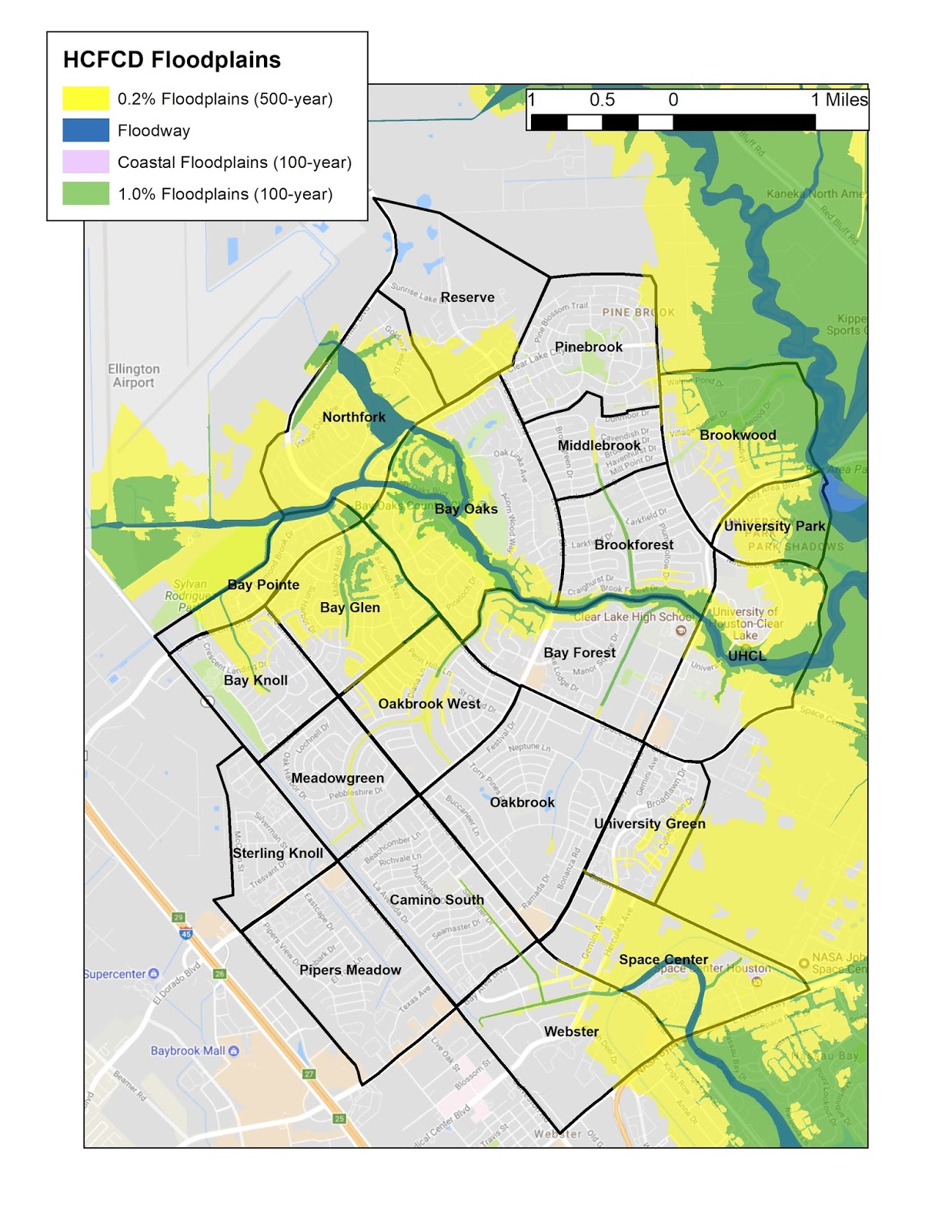
The title of a front page article in today's Houston Chronicle is "County tightens flood plain rules - more rigorous standards for new development could impact growth". http://www.houstonchronicle.com/news/politics/houston/article/County-OKs-stricter-development-rules-aimed-at-12408266.php?cmpid=gsa-chron-result The result is that there will now be new, tougher regulations for flood plain development in Harris County. New construction will be required to be built to the 500-yr storm standard rather than the current 100-yr standard. For Clear Lake City the 500-yr floodplain (yellow on the display below) covers much more area than does the 100-yr (green and blue on the display). The change to the new regulations would effectively be a large expansion of the current SFHAs. For example the Reserve at Clear Lake City currently under development would have to consider the 500-yr flood plain over the southern third of the area. At present the entire area is
Where was damage from Harvey in the Clear Lake City area?
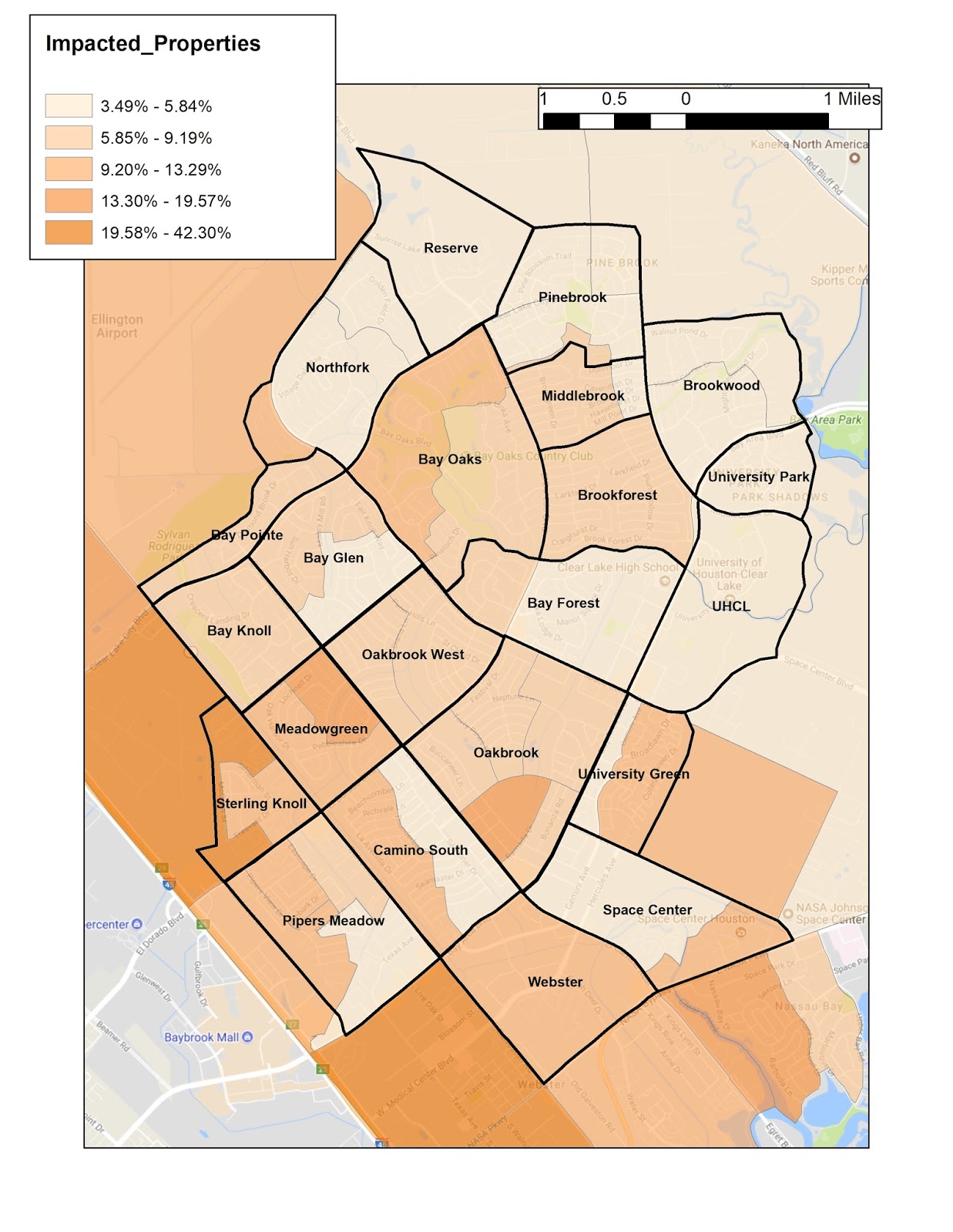
Actual flooding and damage to houses and structures is compiled by FEMA in the form of claims made to the National Flood Insurance Program (NFIP). This information for individual structures is privacy-protected and not available to the public. Customarily the only information available concerning flooding history is the Comprehensive Loss Underwriting Exchange (CLUE) report provided to home buyers by insurance agents. However a knowledgeable Geographic Information Systems (GIS) mapper can research and present various data to illustrate flooding history. The attached example shows the percentage of properties impacted by Harvey, mapped by Census Tract Block Groups in the Clear Lake City (CLC) area. These block groups quite often coincide with the CLC neighborhoods. This data is based on the number of applicants to FEMA for disaster assistance, so it is not limited to NFIP policyholders only. Note the very low percentages of damaged properties in the neighborhoods on the
FEMA published a predictive model for flooding during Harvey - was it accurate?

On August 27, 2017 FEMA published a Damage Assessment Model listing predicted inundation depths and degrees of damage at the level of individual land parcels throughout the Houston area. The methodology by which this was produced is described in a document at the link below: https://data.femadata.com/NationalDisasters/HurricaneHarvey/Data/DamageAssessments/ Although the publication of this model was too late to guide study area resident decisions concerning preventive measures and evacuation, it does provide an illustration of areas and structures potentially at risk during another major rainfall event. Particularly notable is the concentration of points in the Brookwood neighborhood adjacent to Armand Bayou. Information to be presented in a future post shows that damage was relatively light in that area. However there were significant numbers of flooded parcels throughout Clear Lake City that were not predicted by this model. Does this model provide any insigh
Where are the high flooding risk areas of Clear Lake City, TX?
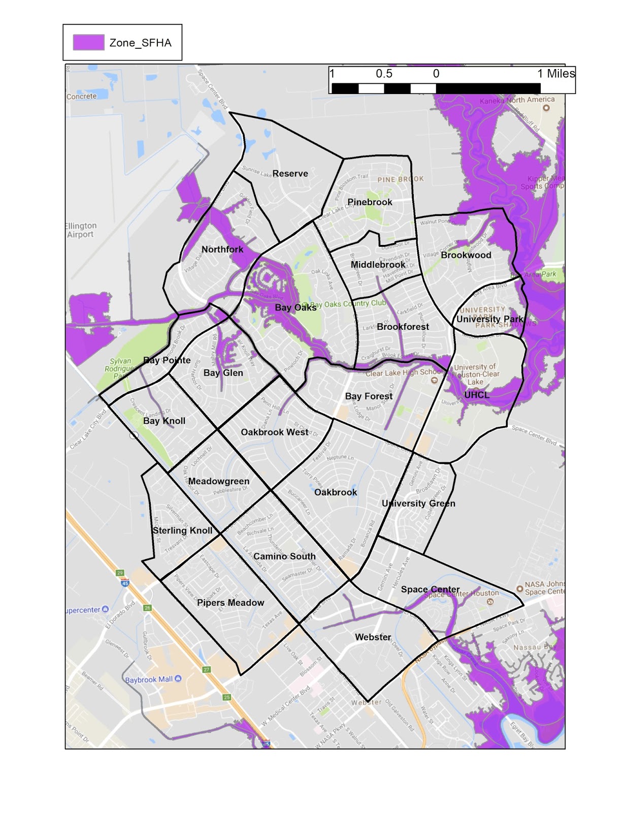
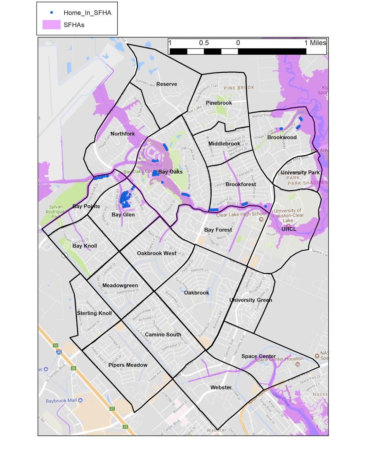
The areas with the highest risks for flooding are mapped as Special Flood Hazard Areas (SFHA). Special Flood Hazard Areas represent the area subject to inundation by 1-percent-annual chance flood. Structures located within the SFHAs have a 26-percent chance of flooding during the life of a standard 30-year mortgage. Federal floodplain management regulations and mandatory flood insurance purchase requirements apply in these zones. In Clear Lake City the Armand Bayou, Horsepen Bayou, and Cow Bayou drainages and tributary ditches compose the SFHAs. The Bay Glen and Bay Oaks neighborhoods in particular have multiple houses located in current SFHAs. Many other houses in these and other neighborhoods are mapped as partially within SFHAs. Note the location of your home in relation to the SFHAs. Does this map help you to understand why flooding did (or did not) happen in your neighborhood?
Did your home flood unexpectedly in in the Clear Lake City area of SE Houston?
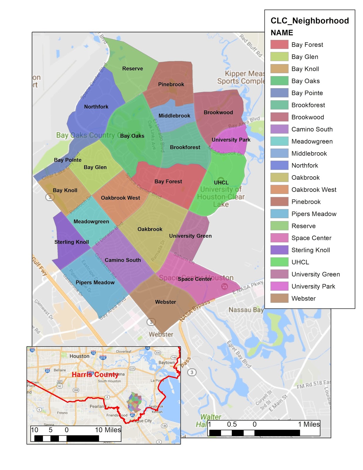
Clear Lake City is located in SE Harris County, TX. It includes twenty-one subdivisions developed beginning in the late 1960s and continuing to the present. There are significant areas with high flooding risk, however the area has generally avoided serious damage from major storms during that time. The recent Hurricane Harvey event provides a case study for examination of the accuracy of the predictive value provided by Flood Insurance Risk Maps (FIRM) developed by FEMA. The patterns of water accumulation and the resulting damage will be presented in future posts as a basis for discussion and further investigation. If your home or neighborhood is located in a low flooding risk area according to the FIRM but had significant water damage please join in the discussion. Let's examine the possible causes and implications for the future.